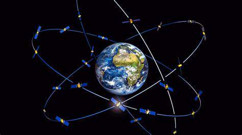
The Galileo Navigation System
Developed as a flagship project of the European Union, the Galileo navigation system represents a major leap forward in global positioning technology. Unlike traditional GPS systems, Galileo was specifically engineered to deliver superior accuracy and reliability for civilian applications. What sets Galileo apart is its independence from military control, ensuring uninterrupted service even during geopolitical tensions. This characteristic makes it indispensable for time-sensitive operations like emergency response coordination and air traffic control.
With its constellation of medium earth orbit satellites, Galileo achieves remarkable positioning precision - often within centimeters for authorized users. The system's dual-frequency capability significantly reduces atmospheric interference that plagues single-frequency systems. For industries like precision agriculture and autonomous transportation, this level of accuracy translates to measurable improvements in efficiency and safety. Recent upgrades have further enhanced Galileo's resilience against jamming and spoofing attempts, critical features for maritime navigation and military applications.
GLONASS: Russia's Global Navigation Satellite System
Originally developed during the Cold War era, Russia's GLONASS has evolved into a sophisticated positioning network with global coverage. The system utilizes a unique orbital configuration that provides better performance at high latitudes compared to GPS, making it particularly valuable for Arctic operations. GLONASS's strength lies in its robust signal structure, which maintains functionality even in challenging urban environments with tall buildings.
Modern GLONASS satellites incorporate advanced atomic clock technology that rivals the stability of GPS systems. The Russian government has prioritized GLONASS modernization, with recent satellites featuring improved resistance to electronic warfare threats. For transportation networks spanning Russia's vast territory, GLONASS provides critical redundancy that ensures continuous operation even if other systems become unavailable. The system's integration with Russia's emergency response infrastructure demonstrates its vital role in public safety applications.
Complementing GPS: The Importance of Multi-Constellation Systems
The synergy between Galileo, GLONASS, and GPS creates a positioning infrastructure far more capable than any single system. Modern receivers that process signals from all three constellations benefit from increased satellite visibility, especially in urban canyons or mountainous terrain. This multi-source approach reduces the geometric dilution of precision (GDOP), yielding position fixes that are both more accurate and more reliable.
Aviation provides a compelling case study for multi-constellation benefits. During approach and landing phases, aircraft can maintain the required navigation performance (RNP) parameters more consistently by using all available GNSS signals. The redundancy provided by multiple independent systems is transforming safety-critical applications across transportation, telecommunications, and energy distribution networks.
Enhanced Accuracy and Resilience: Beyond Basic Positioning
Contemporary GNSS systems have evolved into sophisticated timing networks that underpin global financial markets and telecommunications infrastructure. The nanosecond-level synchronization enabled by these systems is crucial for 5G network operation and high-frequency trading platforms. During natural disasters when terrestrial timing references fail, GNSS timing becomes the backbone of emergency communication systems.
Scientific applications also benefit enormously from GNSS advancements. Tectonic plate monitoring stations use millimeter-level positioning to track continental drift, while atmospheric scientists employ signal delays to study ionospheric disturbances. These capabilities are revolutionizing our understanding of Earth systems and improving early warning systems for space weather events.
Applications in Diverse Fields
The proliferation of GNSS technology has enabled transformative applications across unexpected domains. In agriculture, centimeter-accurate positioning allows for variable-rate application of inputs, reducing environmental impact while improving yields. The construction industry now relies on GNSS-guided machinery that can execute complex earthworks with minimal human intervention.
Emerging Internet of Things applications demonstrate GNSS's expanding role. Asset tracking systems combine GNSS with low-power wide-area networks to monitor high-value shipments globally. Smart city initiatives leverage precise timing and positioning to optimize everything from traffic light sequencing to drone delivery networks. Even wildlife researchers now use miniature GNSS tags to track animal migrations with unprecedented detail.
Challenges and Future Directions in GNSS Technology

Addressing the Ethical Implications
As GNSS positioning becomes more precise and ubiquitous, important questions emerge about location privacy and surveillance capabilities. The ability to track individuals or assets with centimeter accuracy creates tension between security benefits and personal privacy rights. Regulatory frameworks must evolve to address these concerns while preserving GNSS's societal benefits.
Navigating the Data Deluge
Modern GNSS receivers generate vast amounts of raw measurement data that can reveal detailed movement patterns. Developing efficient methods to process and analyze this data while preserving its utility represents a significant computational challenge. Advanced filtering algorithms and edge computing solutions are emerging to address this data management bottleneck.
Ensuring Robustness and Security
The threat landscape for GNSS systems continues to evolve, with sophisticated spoofing attacks becoming more prevalent. Recent incidents have demonstrated how GNSS vulnerabilities can disrupt shipping, aviation, and even financial systems. Next-generation anti-jamming technologies and cryptographic signal authentication are critical areas of development.
Fostering Collaboration and Knowledge Sharing
International cooperation remains essential for maintaining and improving global navigation systems. The International Committee on GNSS (ICG) plays a vital role in coordinating system interoperability and spectrum management between nations. Such collaboration ensures that GNSS continues to serve as a global public good.
Developing Explainable Positioning
As GNSS becomes integrated with machine learning systems, understanding position solution confidence levels grows more important. New integrity monitoring approaches provide users with real-time estimates of positioning uncertainty, enabling better decision-making in safety-critical applications.
Addressing the Skills Gap
The growing complexity of GNSS technology creates demand for specialists who understand both satellite navigation and adjacent fields like RF engineering. Educational programs that combine theoretical foundations with practical receiver development experience are helping to cultivate this next generation of experts.
Promoting Responsible Innovation
Balancing rapid technological advancement with thoughtful consideration of societal impacts remains an ongoing challenge. Industry forums and standards bodies play crucial roles in establishing best practices for GNSS implementation across different application domains. This ensures that navigation technology develops in ways that maximize public benefit.
The Future of GNSS and its Impact on Society
GNSS Evolution and Technological Advancements
The next decade will witness transformative changes in satellite navigation technology. New mega-constellations in low Earth orbit promise to augment traditional GNSS with additional ranging signals, potentially improving availability in urban canyons. Innovations in quantum-enhanced atomic clocks could revolutionize timing precision, enabling entirely new classes of scientific and commercial applications.
Enhanced Accuracy and Precision
Emerging techniques like precise point positioning (PPP) are eliminating the need for ground reference stations while maintaining centimeter-level accuracy. These advancements will make high-precision positioning accessible to mass-market applications, from smartphone navigation to consumer drones. Real-time kinematic (RTK) solutions are becoming more robust through network densification and improved atmospheric modeling.
Increased Accessibility and Coverage
The integration of GNSS with alternative positioning technologies (like LEO satellite signals and 5G networks) will ensure continuous coverage in challenging environments. This hybrid approach promises to finally solve the urban canyon problem that has limited GNSS reliability in dense cities. Emerging markets stand to benefit enormously from these improvements in accessibility.
Integration with Other Technologies
The convergence of GNSS with artificial intelligence and edge computing will enable intelligent positioning systems that adapt to environmental conditions. Autonomous vehicles will leverage these integrated systems to make navigation decisions with unprecedented contextual awareness. The combination of precise timing and location data will also accelerate innovations in augmented reality applications.
Impacts on Society and the Economy
As GNSS becomes more deeply embedded in critical infrastructure, its economic impact will continue to grow exponentially. Industries from logistics to telecommunications now consider precise positioning and timing as essential utilities rather than optional features. The societal benefits range from improved emergency response times to more efficient transportation networks that reduce environmental impacts.