Introduction to Satellite Technology for Infrastructure Damage Detection
Fundamentals of Satellite Technology
Modern satellite systems represent an extraordinary fusion of physics and engineering, enabling global connectivity and environmental monitoring that was unimaginable a century ago. Rather than just understanding orbital mechanics, contemporary researchers emphasize the practical implications of these systems for disaster response and infrastructure assessment. The true value lies in how these artificial eyes in the sky can detect millimeter-level structural changes in bridges or buildings before human inspectors notice any issues. This technological evolution continues to reshape our approach to maintaining critical infrastructure worldwide.
Positioning satellites involves more than just mathematical calculations - it's about creating a responsive network that adapts to Earth's dynamic systems. The relationship between orbital altitude and coverage area determines whether a satellite can monitor specific infrastructure projects continuously or only during periodic passes. This operational nuance makes all the difference when tracking gradual structural deterioration.
Operational Satellite Varieties in Infrastructure Monitoring
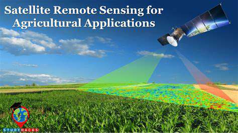
While communication satellites dominate public awareness, synthetic aperture radar (SAR) satellites have become the unsung heroes of infrastructure monitoring, capable of detecting ground movement with millimeter precision regardless of weather conditions or daylight. These specialized instruments peer through cloud cover - a capability that optical satellites simply can't match - making them indispensable for year-round structural assessments.
Recent advancements in thermal imaging satellites now allow engineers to identify overheating electrical components in power grids or detect insulation failures in large industrial complexes. This preventive maintenance application demonstrates how satellite capabilities are evolving beyond simple observation into predictive analytics tools.
Precision Positioning for Infrastructure Applications
The mathematics behind satellite orbits transforms into practical benefits when applied to infrastructure monitoring. Geostationary satellites provide constant surveillance of specific regions, while sun-synchronous orbits offer consistent lighting conditions for visual comparisons over time. This orbital diversity creates complementary datasets that, when combined, provide a comprehensive view of structural health.
Modern ground control systems leverage AI to make micro-adjustments to satellite trajectories, ensuring optimal positioning for monitoring critical infrastructure projects. These constant refinements maximize the utility of each satellite pass, collecting data with ever-increasing relevance to engineers and safety inspectors.
Data Transmission Innovations
The latest generation of satellites employs adaptive frequency hopping to maintain data integrity even in electromagnetically noisy urban environments. This technological leap ensures that crucial infrastructure damage reports reach decision-makers without interference or delay, enabling faster response to potential structural failures.
Ground station networks have evolved to process incoming satellite data in real-time, using edge computing to prioritize urgent structural alerts. This shift from periodic reporting to continuous monitoring represents a paradigm change in how we safeguard critical infrastructure assets.
Emerging Capabilities in Structural Health Monitoring
The next frontier involves satellite constellations specifically designed for infrastructure monitoring, with planned deployments offering hourly updates on critical structures. When combined with IoT sensor data from the structures themselves, this satellite-network approach creates an unprecedented early warning system for potential structural failures.
Machine learning algorithms now process years of satellite imagery to establish baseline structural behavior patterns, automatically flagging deviations that might indicate developing problems. This predictive capability moves infrastructure maintenance from reactive to proactive, potentially saving billions in emergency repairs and preventing catastrophic failures.
Utilizing Multispectral and Hyperspectral Imagery for Damage Identification

Advanced Spectral Analysis Techniques
Modern spectral imaging systems now incorporate quantum dot technology, achieving spectral resolutions that reveal material stress patterns invisible to previous generations of sensors. This breakthrough enables detection of microfractures in concrete and early-stage corrosion in steel structures long before these issues become visible to human inspectors. The implications for bridge and building maintenance are profound.
Innovative processing algorithms now extract material stress indicators from subtle spectral variations, creating detailed structural health maps. These maps don't just show current damage - they can predict areas likely to develop problems based on material fatigue patterns.
Hyperspectral Applications in Material Science
The latest hyperspectral sensors can distinguish between different concrete curing stages or identify improperly mixed construction materials. This capability is revolutionizing quality control in large-scale construction projects, allowing remote verification of material specifications across entire building sites.
Advanced classification algorithms now map material degradation timelines, helping engineers prioritize repairs based on actual remaining structural integrity rather than visual inspection alone. This data-driven approach optimizes maintenance budgets and extends infrastructure lifespans.
Thermal Anomaly Detection
Modern multispectral systems combine thermal bands with visual spectra to detect energy leaks in buildings or overheating in electrical infrastructure. This dual-spectrum approach identifies problems that would escape notice using either spectrum alone, providing a more complete picture of structural health.
Automated change detection algorithms now track thermal signature evolution over time, spotting degradation trends in roofing materials or insulation systems. This longitudinal analysis helps facility managers implement preventive maintenance before energy losses become significant.
Leveraging Machine Learning for Enhanced Accuracy and Efficiency
Automated Defect Recognition Systems
Contemporary machine learning systems now employ few-shot learning techniques, achieving high accuracy in damage detection even with limited training data. This advancement is particularly valuable for identifying rare but critical structural failures, where historical examples may be scarce but consequences are severe.
Neural networks trained on global infrastructure datasets can now recognize context-specific damage patterns, understanding that a crack pattern means different things in a desert bridge versus an arctic pipeline. This geographical awareness reduces false positives and improves diagnostic accuracy.
Predictive Maintenance Algorithms
Advanced time-series analysis of satellite data now predicts maintenance needs months in advance by identifying subtle change patterns human analysts would miss. These predictive models incorporate weather data, material specifications, and usage patterns to forecast when and where repairs will be needed.
The latest systems generate probabilistic failure maps, showing not just where damage exists but the likelihood of future failures. This risk-based approach helps municipalities and corporations allocate limited maintenance resources most effectively.
