Satellite-Based Remote Sensing for Environmental Monitoring
Satellite-Based Remote Sensing Technology
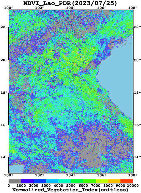
Satellite-based remote sensing has fundamentally changed how we observe our planet. Unlike traditional ground-based methods, this approach leverages advanced sensors orbiting Earth to capture critical environmental data. The global coverage and consistent data collection make it indispensable for tracking large-scale ecological changes. From urban sprawl to melting ice caps, satellites provide insights unmatched by any other tool. Researchers particularly value this technology for studying regions where physical access is limited or dangerous.
Tracking Deforestation Patterns
Modern satellites excel at detecting forest loss with remarkable precision. By comparing sequential images, analysts can spot even subtle changes in tree cover. This capability proves vital for enforcing logging regulations and protecting endangered ecosystems. Timely alerts about illegal clearing operations enable authorities to intervene before irreparable damage occurs. Moreover, the historical data collected helps establish baseline conditions and measure conservation program effectiveness over decades.
Glacier Monitoring Techniques
Ice-covered regions present unique challenges that satellites help overcome. Specialized instruments measure glacier thickness fluctuations down to centimeter accuracy. These measurements reveal how quickly ancient ice formations are disappearing due to climate shifts. Scientists use this information to predict water supply changes for millions who depend on glacial meltwater. The data also improves flood risk assessments for communities downstream of unstable ice formations.
Urban Growth Analysis
City planners increasingly rely on orbital imagery to manage metropolitan expansion. High-resolution photos document how concrete replaces green spaces over time. This visual evidence supports smarter zoning decisions and infrastructure development. By identifying heat island effects early, officials can implement cooling strategies before temperatures become unbearable. The imagery also helps calculate the environmental impact of new construction projects.
Water Resource Management
Drought-prone regions benefit tremendously from satellite water monitoring. Special sensors detect moisture levels in soil and vegetation, signaling emerging dry conditions. River flow measurements aid flood prediction models, giving communities advance warning. Underground aquifers leave subtle surface clues that satellites can detect, helping locate new freshwater sources. These capabilities are transforming how nations manage their most precious resource.
Agricultural Optimization
Farmers worldwide now access satellite data to boost crop yields sustainably. Multispectral imaging reveals nutrient deficiencies invisible to the naked eye. This allows targeted fertilizer application, reducing costs and pollution. Early detection of pest infestations through vegetation stress patterns prevents widespread crop losses. Irrigation systems become more efficient when guided by precise soil moisture maps.
Disaster Response Coordination
When natural disasters strike, satellites provide the first comprehensive damage assessments. Emergency teams use these images to prioritize rescue efforts and resource distribution. The before-and-after comparisons prove invaluable for insurance claims and rebuilding plans. Volcanic activity monitoring gives populations crucial evacuation time when eruptions threaten. This technology has become the backbone of modern emergency management systems.
Drone-Based Remote Sensing for Localized Environmental Studies
The Drone Revolution in Data Collection
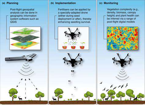
Compact unmanned aircraft have democratized aerial surveying. Their ability to hover and maneuver precisely captures details that satellites might miss. Unlike traditional aircraft, drones can operate below cloud cover for consistent results. Environmental researchers particularly appreciate how easily they adapt to different sensor configurations. This flexibility makes drones ideal for everything from wildlife tracking to pollution monitoring.
The cost savings compared to manned flights allow more frequent surveys. Small organizations can now afford professional-grade geographic data. Real-time data transmission enables immediate analysis during field work. These advantages explain why drone use has exploded across multiple industries in recent years.
Industry-Specific Applications
Agriculture benefits tremendously from drone technology. High-resolution crop health maps guide precision farming practices. Growers detect irrigation problems before plants show visible stress. This proactive approach boosts yields while conserving water and chemicals.
Construction teams employ drones for safer, more efficient site inspections. Close-up imagery reveals structural weaknesses without risking worker safety. Thermal cameras spot insulation gaps in buildings, while laser scanners create millimeter-accurate 3D models. Regular drone surveys document project progress for stakeholders.
Ecologists track endangered species through drone-mounted cameras. The quiet electric motors disturb wildlife less than traditional survey methods. Coastal researchers map erosion patterns with unprecedented detail. These applications demonstrate how drones complement satellite data with hyper-local precision.
Urban designers create living models of cities using drone photogrammetry. The resulting 3D maps help visualize proposed developments in context. Traffic pattern analysis improves when viewed from optimal aerial perspectives. Municipalities save millions by identifying infrastructure needs before failures occur.