Satellite-Based Water Cycle Measurements
Satellite Observations of Precipitation
Modern satellites have revolutionized our ability to observe precipitation patterns globally. These space-based systems offer unparalleled coverage, capturing data across continents and oceans where ground stations are sparse. Advanced radar and microwave instruments orbiting Earth can distinguish between rain, snow, and hail while measuring intensity with remarkable precision. Such capabilities prove invaluable for predicting flash floods, assessing drought severity, and optimizing irrigation schedules in agriculture.
Various satellite sensors specialize in different precipitation types. Some excel at detecting gentle showers that might escape traditional weather radar networks, while others focus on torrential downpours that threaten communities with flooding. Meteorologists combine data from multiple satellite platforms to create comprehensive precipitation maps, enhancing the accuracy of both short-term weather forecasts and long-term climate models.
Tracking Evaporation and Plant Water Use
Space technology now enables scientists to measure how water transforms from liquid to vapor across entire landscapes. This capability transforms our understanding of how moisture moves through ecosystems and the atmosphere. Farmers and water managers particularly benefit from these insights when planning irrigation schedules or assessing regional water budgets.
By analyzing satellite measurements of ground temperature, atmospheric humidity, and vegetation health, researchers can calculate evaporation rates with surprising accuracy. These datasets reveal how climate change alters water cycling patterns, showing which regions may face future shortages. Continuous monitoring from orbit also helps validate computer simulations of hydrological processes, leading to more reliable water resource predictions.
Hydrologists increasingly rely on satellite-derived evaporation data to improve their models. When real-world observations match theoretical predictions, it confirms the model's accuracy. Discrepancies highlight areas needing refinement, driving scientific progress in water cycle understanding.
Applications of Space-Based Monitoring
Environmental Surveillance From Orbit
Satellites provide game-changing capabilities for environmental protection. Their cameras can spot illegal logging operations in remote rainforests, track oil spills across oceans, and document urban expansion into natural habitats. Conservation groups use this information to prioritize protection efforts and hold polluters accountable. During wildfires or floods, satellite imagery guides emergency responders to the most critical areas.
Forecasting Natural Hazards
Space-based data powers advanced warning systems for droughts, floods, and other climate extremes. By combining historical records with current observations, scientists can predict water shortages months before reservoirs run dry. These forecasts allow farmers to adjust planting schedules and help cities implement water conservation measures proactively.
Emerging applications include tracking conditions that enable disease outbreaks, such as standing water where mosquitoes breed or vegetation changes that push disease-carrying animals into human settlements.
Urban Development Insights
City planners harness satellite imagery to make data-driven decisions about infrastructure. Regular overhead photos reveal traffic bottlenecks, illegal construction, and neighborhoods vulnerable to flooding during storms. This intelligence informs everything from subway expansions to storm drain upgrades, creating more livable, resilient cities.
Precision Agriculture From Space
Farmers now access satellite data showing exactly which fields need water or fertilizer. Crop health maps generated from orbit help agricultural producers maximize yields while minimizing environmental impact. Early detection of pest infestations or drought stress through satellite monitoring can mean the difference between a successful harvest and financial ruin.
Disaster Response Coordination
When earthquakes or hurricanes strike, satellite images provide the first comprehensive damage assessments. Rescue teams use these overviews to identify blocked roads, destroyed bridges, and populations cut off from help. Relief organizations distribute aid more efficiently by seeing exactly where needs are greatest, saving both time and lives.
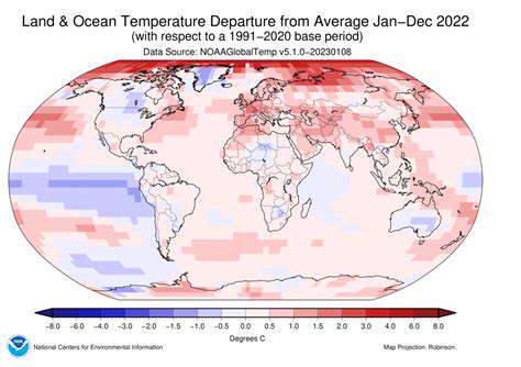
Climate Science Advancements
Decades of satellite records document Earth's changing climate with undeniable clarity. Orbiting sensors track melting glaciers, shifting rainfall patterns, and rising sea levels - all crucial evidence for climate models. This long-term perspective helps distinguish natural variability from human-caused changes, informing global policy decisions about emissions reductions and adaptation strategies.
The Role of Space in Sustainable Water Management
Earth Science From a Cosmic Perspective
Studying other planets provides unexpected insights about our own. Comparative planetology reveals how unique Earth's water cycle truly is. Mars' dried-up river valleys and Venus' runaway greenhouse effect serve as cautionary tales about water resource management. Satellite views of Earth as a blue marble emphasize how precious and finite our water resources appear from space.
Orbiting observatories monitor environmental changes invisible from the ground. They detect underground aquifer depletion through precise gravity measurements and track pollution plumes crossing international borders. This big-picture perspective is essential for coordinated global water governance.
Space Tech for Earth Sustainability
Innovations originally developed for space missions frequently benefit water conservation on Earth. Lightweight filtration systems created for spacecraft now provide clean drinking water in disaster zones. Satellite-based internet connects remote water monitoring stations, creating smart water grids that reduce waste.
Navigation satellites enable precision agriculture, helping farmers apply just enough water exactly where crops need it. This technology prevents both water shortages from under-irrigation and pollution from excess fertilizer runoff. Similar systems optimize municipal water distribution networks, detecting leaks in pipelines before they become crises.
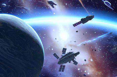
Extraterrestrial Resources and Earth's Future
Space mining could relieve pressure on Earth's water supplies. Asteroids contain water ice that might someday supplement terrestrial sources for space colonies. More immediately, the technologies developed for extracting water in space are being adapted to improve water recycling systems on Earth.
The challenge of sustaining human life in space drives innovations in water purification and conservation that benefit water-scarce regions on our planet. Closed-loop life support systems designed for Mars missions could eventually enable arid regions to reuse every drop of water with minimal loss.
Global Cooperation Through Space Programs
International space stations and satellite constellations demonstrate how nations can collaborate on complex technological projects. This model of shared infrastructure and open data exchange could transform global water management. Just as weather satellites serve all nations regardless of borders, future water-monitoring systems may operate as global public goods.
Joint space missions build trust between nations that could extend to transboundary water agreements. The scientific diplomacy practiced in space programs offers a template for resolving conflicts over shared rivers and aquifers through evidence-based negotiation rather than political posturing.