Illuminating Ocean Ecosystems Through Advanced Remote Sensing
Cutting-Edge Techniques for Monitoring Ocean Productivity
Modern remote sensing technologies, leveraging both satellite and airborne platforms, have revolutionized our ability to study marine ecosystems. These sophisticated systems capture critical data about ocean surface characteristics - from light reflectance patterns to thermal profiles and chlorophyll distribution. This wealth of information enables researchers to track phytoplankton blooms with unprecedented accuracy, providing vital insights into the foundation of marine food chains. Such monitoring has become indispensable for assessing how climate change and human activities are transforming our oceans.
Advanced sensor arrays, including both multispectral and hyperspectral imaging systems, now deliver exceptionally detailed spectral data. This technological capability allows precise identification and measurement of various oceanic components, from microscopic phytoplankton communities to water turbidity levels that directly affect sunlight penetration and photosynthetic activity.
Advanced Phytoplankton Bloom Mapping
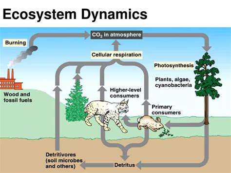
Contemporary satellite imaging systems excel at detecting and mapping phytoplankton blooms across vast ocean areas. These microscopic organisms serve as the ocean's primary producers, forming the crucial base of marine food chains. By precisely measuring chlorophyll concentrations - the essential pigment for photosynthesis - orbital sensors can accurately track bloom locations, sizes, and intensities. Such data proves invaluable for assessing marine biodiversity patterns and overall oceanic health.
Comprehending phytoplankton bloom dynamics enables better fisheries management, more accurate fish stock predictions, and improved assessment of environmental impacts on marine productivity. Large-scale bloom events can significantly alter oxygen levels and trigger cascading effects throughout marine ecosystems.
Ocean Color and Chlorophyll Analysis
A fundamental application of remote sensing involves detailed analysis of ocean color variations and chlorophyll concentrations. Fluctuations in these parameters often indicate significant changes in phytoplankton populations and overall marine productivity. Satellite observations enable continuous, large-scale monitoring of these critical indicators, offering comprehensive perspectives on ocean health. Such data has become essential for evaluating climate change impacts and anthropogenic effects on marine environments.
Ocean coloration, influenced by multiple factors including water clarity, phytoplankton density, and suspended particulate matter, represents a key variable in remote sensing studies. Understanding how these elements interact provides deeper insight into the complex mechanisms governing ocean productivity and ecosystem dynamics.
Sea Surface Temperature Monitoring
Tracking sea surface temperature (SST) variations through remote sensing provides another critical dataset for oceanographers. SST fluctuations significantly influence marine current patterns, species distribution, and overall oceanic productivity. Satellite-derived temperature records create continuous, long-term datasets that help identify climate pattern shifts and anomalies. This information proves crucial for understanding climate change impacts on marine ecosystems.
SST monitoring also contributes to our understanding of oceanic heat budgets and their role in global climate regulation. Temperature anomalies often correlate with unusual weather phenomena, marine heatwaves, and species distribution changes - information vital for both scientific research and coastal management planning.
Primary Productivity Estimation
Remote sensing data enables scientists to calculate primary productivity rates - the process by which phytoplankton convert solar energy into organic matter. This fundamental metric reflects overall ocean health and productivity levels. By integrating satellite observations with ecological modeling, researchers gain more complete understanding of the processes driving marine productivity. Such analyses are crucial for assessing human impacts on the ocean's capacity to sustain life.
Accurate primary productivity estimates help scientists predict how marine ecosystems might respond to environmental changes. This data informs conservation strategy development, fisheries management decisions, and climate change impact projections for marine organisms.
Human Impact Assessment
Remote sensing plays an increasingly important role in evaluating human impacts on marine productivity, including pollution and overfishing effects. By monitoring chlorophyll concentrations, SST changes, and other indicators, scientists can track anthropogenic influences on marine ecosystems over time. This capability supports development of sustainable management approaches and mitigation strategies for human-induced ocean degradation.
The integration of satellite data with ecological models provides nuanced understanding of complex relationships between human activities and marine productivity. Such knowledge proves essential for developing effective conservation strategies to ensure long-term ocean health and sustainability.
Revolutionizing Observation Through Satellite Technology
Agricultural Transformation Through Orbital Imaging
Satellite-based agricultural monitoring has fundamentally changed farming practices by delivering precise data on crop health, soil conditions, and water utilization. This technological advancement enables farmers to optimize irrigation schedules, fertilizer application, and pest management, significantly boosting yields while reducing environmental harm. Early detection of crop stress factors like drought or nutrient deficiencies allows proactive intervention, preventing substantial agricultural losses.
The capacity to remotely survey extensive agricultural lands represents a major advantage, facilitating efficient resource distribution and targeted solutions that enhance both productivity and sustainability.
Precision Navigation and Asset Tracking
Satellite navigation systems have become indispensable tools for precise positioning and asset monitoring. Modern farming equipment increasingly incorporates GPS technology, enabling accurate field mapping, automated tractor guidance, and livestock movement tracking. This precision farming approach optimizes resource allocation while lowering operational expenses.
Vehicle and equipment tracking also improves fleet management and safety protocols, particularly valuable for large-scale agricultural operations requiring enhanced visibility and control.
Environmental Monitoring From Space
Orbital platforms provide critical environmental data affecting agricultural productivity. By observing weather systems, deforestation patterns, and land use changes, farmers and policymakers can make better-informed decisions about climate adaptation and natural resource conservation. Satellite data also helps predict environmental risks like floods, droughts, and temperature extremes, enabling preventive measures.
Water resource monitoring represents another key application, with satellites tracking river and reservoir levels to inform irrigation planning and water management strategies, ensuring sustainable usage and preventing shortages.
Disaster Management Applications
During natural disasters, satellites provide essential information for emergency response efforts. Rapid damage assessment, impact zone identification, and agricultural land evaluation are critical for organizing effective relief operations. Orbital imagery quickly maps affected areas, highlighting priority zones and enabling efficient resource distribution for disaster response.
This includes identifying crop damage, assessing infrastructure impacts, and monitoring resource availability in disaster-stricken regions - all vital for coordinating timely assistance.
Global Agricultural Perspectives
The worldwide view provided by satellites offers unparalleled insights into agricultural practices across different regions. This global perspective facilitates identification of best practices and knowledge sharing to enhance food security and sustainability worldwide. Comparative analysis of regional farming methods yields valuable insights about efficiency and effectiveness. Such data empowers researchers and policymakers to develop strategies for improving global agricultural productivity and food security.
By offering comprehensive global agricultural monitoring, satellites help identify both challenges and opportunities for improvement - essential knowledge for developing sustainable food production strategies.