The Impact of Satellite Data on Policy and Public Awareness
Satellite Monitoring of Air Pollution
Satellite technology plays a crucial role in monitoring air pollution on a global scale, providing crucial data that is often unattainable through ground-based monitoring stations alone. These satellites equipped with sophisticated sensors can detect various pollutants, such as nitrogen dioxide, sulfur dioxide, and particulate matter, across vast geographical areas. This comprehensive view is essential for understanding pollution patterns and identifying pollution sources, providing vital information for policymakers and public health officials.
Satellite imagery allows for the visualization of pollution plumes and dispersion patterns, revealing how pollutants move and interact with the atmosphere. This dynamic information is invaluable in understanding the impact of weather systems on air quality and identifying areas experiencing high pollution levels. The continuous data stream from these satellites enables a real-time assessment of air quality, which helps in predicting and responding to pollution events.
Policy Implications of Satellite Data
The data collected by satellites provides policymakers with crucial information for developing and implementing effective air quality management strategies. Analysis of satellite data can pinpoint pollution hotspots, identify industrial sources contributing to pollution, and assess the effectiveness of existing regulations. This information is essential for creating targeted policies that address specific pollution problems and for optimizing the allocation of resources for pollution control initiatives.
Satellite data also allows policymakers to track the progress of air quality improvements over time, providing a benchmark for evaluating the effectiveness of their implemented policies. This evidence-based approach allows for adjustments and refinements in policy measures, leading to more targeted and impactful interventions to reduce pollution and improve public health.
Public Awareness and Engagement
Satellite data can significantly enhance public awareness about air pollution issues. By visualizing pollution levels and patterns through interactive maps and visualizations, satellite data can make complex scientific information easily accessible to the public. This accessibility empowers individuals to understand the impact of air pollution on their health and environment, fostering a sense of shared responsibility for environmental protection.
Public engagement is vital for successful air quality management. Sharing satellite data visualizations and educational materials can empower communities to actively participate in pollution reduction efforts and advocate for policy changes. This heightened awareness can lead to greater public support for environmental protection initiatives and a more informed citizenry.
Improving Air Quality Models
Satellite data significantly enhances the accuracy and predictive power of air quality models. By incorporating satellite-derived data on pollutant concentrations, dispersion, and sources, these models can provide more detailed and reliable forecasts of air quality. This improved prediction capability allows for proactive measures to mitigate potential pollution events, such as issuing health advisories or implementing traffic management strategies.
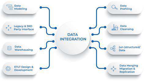
Data Integration and Challenges
Integrating satellite data with other data sources, such as ground-based monitoring networks and meteorological information, is crucial for a comprehensive understanding of air quality. However, challenges exist in ensuring data consistency and compatibility across different platforms. Furthermore, the cost of acquiring and processing satellite data, as well as the complexity of interpreting the data, can pose barriers to its widespread use. Overcoming these challenges is essential for maximizing the benefits of satellite data for both policy and public awareness.