Early Missions and the Dawn of Lunar Cartography
When NASA launched the Lunar Orbiter program in the mid-1960s, it fundamentally transformed our ability to study Earth's nearest celestial neighbor. Before these groundbreaking missions, astronomers relied on Earth-based telescopes that offered limited, blurry views of the lunar surface. The series of Lunar Orbiter spacecraft captured the first comprehensive photographic survey, exposing a landscape far more complex than anyone had anticipated. These images didn't just satisfy scientific curiosity - they became the foundation for humanity's first steps on another world.
The initial five Lunar Orbiter missions focused intensely on creating precise photographic maps covering 99% of the Moon's visible surface. Mission planners needed these detailed views to evaluate potential Apollo landing zones, ensuring astronauts wouldn't encounter dangerous terrain. The exceptional clarity revealed subtle features - from tiny impact craters to slight variations in the vast lunar plains - allowing geologists to reconstruct the Moon's violent history. This cartographic effort didn't just support Apollo; it created the first complete atlas of another world.
Technical Innovations and Image Quality
What made the Lunar Orbiter achievements remarkable was the technological ingenuity overcoming 1960s limitations. Engineers developed a unique dual-lens camera system that captured both wide-angle context shots and high-resolution detail images simultaneously. The spacecraft's film development and scanning system - essentially a flying photographic laboratory - produced images with resolution down to 1 meter, unprecedented for orbital photography at that time.
The quality of these lunar photographs represented a quantum leap in planetary science. Scientists could now identify boulders, measure slope angles, and even spot potential scientific treasures like recent meteor impacts. For the first time, researchers could conduct detailed geological surveys without leaving Earth. These images didn't just inform mission planning; they captivated the public imagination, making the Moon feel tantalizingly within reach.
Impact on Future Lunar Exploration and Scientific Understanding
The Lunar Orbiter program's true significance extends far beyond its original mapping objectives. The photographic archive enabled scientists to identify scientifically valuable landing sites for Apollo, including areas with diverse geology that could reveal the Moon's origins. Mission planners used these images to calculate precise landing coordinates, evaluate surface stability, and even predict how lunar dust might behave during landings.
Beyond immediate mission needs, the program revolutionized our understanding of lunar geology. The images preserved evidence of ancient volcanic flows, massive impact events, and tectonic activity that rewrote theories about the Moon's development. Modern researchers still consult these images when planning new lunar missions or studying long-term surface changes. The program also proved that robotic scouts could safely and productively explore other worlds - a lesson applied to every planetary mission since.
The data revealed unexpected complexities in surface composition, showing regional variations that hinted at the Moon's violent formation. Crater studies provided a new timeline for impacts in the early solar system, while images of mountain ranges suggested surprising tectonic activity. These discoveries continue to shape current lunar research and influence theories about other rocky planets.
Perhaps most importantly, Lunar Orbiter established the methodology for modern planetary exploration. Its careful balance of engineering precision and scientific curiosity created a template followed by subsequent missions to Mars, Venus, and beyond. The program demonstrated that thorough reconnaissance must precede human exploration - a principle guiding NASA's current Artemis program.
Legacy and Impact on Future Missions
Early Pioneers and Lessons Learned
The Lunar Orbiter missions achieved far more than their primary mapping objective - they forged new techniques for exploring alien worlds. Engineers had to innovate solutions for challenges like developing film in space and transmitting high-quality images across 240,000 miles of space. These technological breakthroughs led directly to improvements in spacecraft navigation, deep space communication, and orbital photography that benefit missions to this day.
The program's rigorous approach to testing and problem-solving established best practices still followed in mission planning. When the first Lunar Orbiter's camera malfunctioned, engineers developed a workaround that became standard procedure for troubleshooting spacecraft issues remotely. This mission control mentality fundamentally changed how space agencies approach complex operations. The expertise gained during these missions directly enabled later successes like the Viking Mars landers and Voyager probes.
High-Resolution Imaging and its Significance
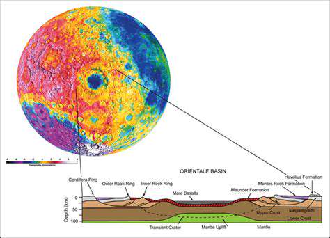
Lunar Orbiter's photographic archive didn't just show the Moon - it revealed a dynamic world with a complex geological history. For the first time, scientists could trace lava flow patterns, measure crater degradation over time, and identify promising locations for future sample returns. The images proved so detailed that contemporary researchers still use them to study changes in the lunar surface over decades.
These photographs also had immediate practical value. Mission planners identified areas with smooth terrain for Apollo landings while also locating scientifically intriguing features nearby. The images even revealed potential resources - like regions with unusually reflective material that might indicate valuable mineral deposits. This combination of scientific and practical analysis set the standard for all subsequent planetary reconnaissance.
Impact on Landing Site Selection for Apollo
Selecting Apollo landing sites required balancing safety concerns with scientific priorities - a challenge made possible only by Lunar Orbiter's detailed surveys. Engineers needed areas free of large boulders and steep slopes, while scientists sought sites that could answer fundamental questions about the Moon's origin. The Orbiter images allowed teams to evaluate hundreds of potential locations before narrowing down to the safest, most interesting options.
The photographs proved so accurate that Apollo astronauts often recognized landmarks from their training. When Neil Armstrong took manual control during the historic Apollo 11 landing, he used crater patterns identified in Orbiter images to guide Eagle to a safe touchdown. This seamless transition from orbital imagery to surface navigation validated the program's meticulous approach and demonstrated the value of high-quality reconnaissance.
Technological Advancements and Future Applications
Many technologies pioneered for Lunar Orbiter found unexpected applications beyond space exploration. The film scanning technology led to advances in medical imaging, while the precision optics influenced satellite surveillance systems. Perhaps most significantly, the program's data transmission techniques became the foundation for modern deep space communication networks.
Current lunar missions still build on Orbiter's legacy. NASA's Lunar Reconnaissance Orbiter, launched in 2009, uses updated versions of the same basic imaging principles to guide new exploration efforts. Commercial lunar landers rely on data from both original Orbiter images and modern surveys to select safe landing zones. This continuity across six decades proves the enduring value of the program's innovations. As humanity returns to the Moon, we're still following the path first charted by these pioneering orbiters.
