Data-Driven Insights for Optimized City Design
Data Collection and Preparation
The foundation of any data-driven approach lies in gathering and preparing high-quality urban data. Cities must identify which metrics truly matter—whether it's traffic flow patterns, energy consumption rates, or demographic shifts—and develop systematic ways to capture this information. Flawed data collection methods inevitably produce misleading results, making rigorous protocols non-negotiable. Urban planners often spend 60-80% of their analysis time just cleaning and standardizing datasets before any meaningful work begins.
Preparation goes beyond technical formatting. Teams must scrutinize data sources for hidden biases—does our sensor network only cover affluent neighborhoods? Are we missing informal settlements in our surveys? This critical examination separates superficial number-crunching from genuinely representative urban intelligence. Many cities now employ data wranglers specifically for this validation process.
Defining Urban Performance Metrics
Rather than generic KPIs, successful cities develop hyper-local indicators that reflect their unique challenges. A coastal city might prioritize flood resilience metrics, while a rapidly growing metropolis could focus on housing affordability indices. The key is selecting 5-7 truly decisive metrics rather than drowning in hundreds of vanity statistics.
Singapore's Digital Urban Twin initiative exemplifies this well—they track just six core indicators for neighborhood vitality, but each connects directly to policy levers. This ruthless focus prevents analysis paralysis and ensures every data point drives concrete actions.
Advanced Spatial Analysis Methods
Modern urban analytics employ techniques far beyond basic statistics. Geospatial machine learning can reveal hidden patterns in pedestrian flows, while network analysis optimizes emergency response routes. Barcelona's Superblocks project used agent-based modeling to simulate how urban design changes would affect social interactions and pollution levels.
The most impactful analyses often come from combining methods—layering demographic clustering algorithms with real-time mobility data, for instance. This multidimensional approach helps avoid the tunnel vision that plagues single-method studies.
Urban Predictive Analytics
Forward-looking cities now deploy predictive models that anticipate challenges months or years in advance. Chicago's Array of Things initiative uses environmental sensors and machine learning to predict heat islands before they form, allowing targeted tree-planting. These models become more accurate as they ingest real-time IoT data from smart city infrastructure.
The real power emerges when predictions trigger automatic responses—like dynamically adjusting traffic signals based on forecasted congestion patterns. However, modelers must continually audit for concept drift as urban systems evolve.
Visual Storytelling for Urban Data
Effective visualization transforms complex urban data into compelling narratives. Interactive dashboards like Amsterdam's City Dashboard allow residents to explore affordability trends across neighborhoods. 3D heatmaps can reveal invisible patterns—like how building heights create wind tunnels that intensify pollution.
The best urban data visualizations don't just present information—they make the case for specific policy interventions through intuitive design. Copenhagen's climate adaptation plans use before/after flood modeling visuals that convinced skeptical stakeholders.
From Insights to Action
The true test comes when data meets real-world implementation. Seoul's 2030 Digital Master Plan ties every initiative to verifiable metrics—if a smart parking system doesn't reduce circling traffic by 15%, it gets redesigned. This creates a culture where data isn't just collected—it demands accountability.
Most importantly, cities must build feedback loops. Singapore recalibrates its models quarterly based on ground truth verification—recognizing that urban systems are living organisms, not static datasets.
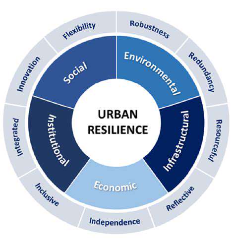
Predictive Modeling for Urban Resilience
Next-Generation Urban Forecasting
Modern urban forecasting now blends traditional statistical methods with cutting-edge approaches. Tokyo's earthquake response system combines physics-based simulations with AI that learns from thousands of past tremors. The breakthrough comes from fusing different modeling paradigms—no single approach captures urban complexity.
Emerging techniques like digital twins create living models that update in real-time as sensors feed new data. Rotterdam's water management system exemplifies this, adjusting flood predictions minute-by-minute based on rain gauge and tide monitor inputs.
Unconventional Data Streams
Progressive cities now mine unexpected data sources for resilience insights. Barcelona analyzes mobile signal densities to map crowd movements during emergencies. São Paulo uses delivery app data to identify neighborhoods vulnerable to supply chain disruptions.
The most innovative models incorporate soft data—like social media sentiment analysis during heatwaves to pinpoint where vulnerable populations need cooling centers. However, cities must navigate privacy concerns through careful anonymization protocols.
Stress-Testing Urban Models
Rigorous validation separates useful models from academic exercises. Mexico City runs its earthquake models against historical events they weren't trained on—if they can't predict past disasters accurately, they're retrained. This adversarial testing builds confidence in model reliability before real crises hit.
Some cities now use red team approaches, where separate groups try to break each other's models by finding edge cases—like how transport models handle bridge failures during evacuations.
Anticipatory Urban Design
Forward-thinking applications are transforming city planning. Helsinki uses predictive analytics to site new schools where demographic models show future family growth. Los Angeles' Climate Vulnerability Index directs infrastructure investments to neighborhoods most at risk from rising temperatures.
The most sophisticated systems now run continuous what-if simulations—testing how proposed policies might play out across different climate change scenarios.
Resilience Through Prediction
True urban resilience means anticipating crises before they escalate. Singapore's dengue fever predictions trigger targeted mosquito control in specific blocks weeks before outbreaks would occur. This shift from reactive to predictive governance represents the pinnacle of urban intelligence.
New York's Rainfall Ready program illustrates this perfectly—drainage upgrades now target areas that models show will face extreme precipitation in the 2030s, not just current flood zones.
The Ethics of Predictive Urbanism
As models grow more powerful, cities must address emerging dilemmas. Should predictive policing algorithms be used if they might reinforce biases? How transparent should flood risk models be to avoid property value impacts? The next frontier isn't technical—it's developing governance frameworks for responsible model use.
Amsterdam's Algorithm Register sets a benchmark by publicly documenting all city-used algorithms and their potential societal impacts—an approach gaining global traction among ethical urban planners.