Swarm Satellite Applications in Distributed Sensing
Distributed sensing, enabled by constellations of small, low-cost satellites, represents a paradigm shift in Earth observation. This approach, often referred to as swarm technology, allows for unprecedented spatial and temporal coverage, providing a more comprehensive and dynamic view of our planet. By deploying numerous satellites, each collecting data in a specific area or focused on a specific parameter, scientists gain a much richer understanding of phenomena that are difficult to capture with traditional, single-satellite missions. This increased data density unlocks valuable insights into complex environmental processes, from monitoring deforestation and agricultural yields to tracking pollution patterns and studying climate change.
The implications of this technology extend far beyond scientific research. Real-time monitoring of natural disasters, such as floods and wildfires, becomes significantly more effective with widespread coverage. Early warning systems can be enhanced, allowing for quicker response and potentially saving lives. Furthermore, the applications in precision agriculture are vast, enabling farmers to optimize resource use and improve crop yields based on real-time data about soil moisture, plant health, and weather patterns. The ability to gather this precise data from diverse locations simultaneously is a game-changer.
Beyond the Satellite: Data Fusion and Analysis
The power of distributed sensing lies not just in the sheer volume of data collected, but also in the ability to fuse and analyze this information effectively. This requires sophisticated data processing techniques and algorithms, which are continually being developed to handle the complexities of integrating data from numerous sources and locations. Developing robust, scalable platforms to ingest, process, and store the vast datasets generated by these constellations is a significant challenge, but also a critical component for realizing the full potential of distributed sensing.
Furthermore, the integration of data from various sensors, including ground-based instruments and other satellite systems, is crucial. This fusion of data allows for a more complete picture of the phenomena under investigation. For example, combining satellite imagery with ground-based measurements of air quality can provide a more nuanced understanding of pollution sources and dispersion patterns. The development of advanced algorithms for data fusion and analysis is essential for the accurate interpretation and application of this wealth of information.
The potential applications of such data fusion extend beyond environmental monitoring. Urban planning and infrastructure management can benefit greatly from real-time data on traffic patterns, energy consumption, and building usage. This enhanced understanding allows for more efficient resource allocation and sustainable development strategies. Ultimately, distributed sensing promises a more interconnected and data-driven approach to understanding and managing our planet.
The development of robust, scalable platforms to ingest, process, and store the vast datasets generated by these constellations is a significant technological hurdle, but also a critical component for realizing the full potential of distributed sensing.
Effective data analysis, through the use of machine learning and AI, is another crucial aspect of unlocking the true value of the vast datasets generated by distributed sensing. These sophisticated computational tools can identify patterns, trends, and anomalies that might otherwise be missed in traditional analyses. This allows for more accurate predictions, proactive responses, and the development of innovative solutions to pressing global challenges.
Applications in Environmental Monitoring
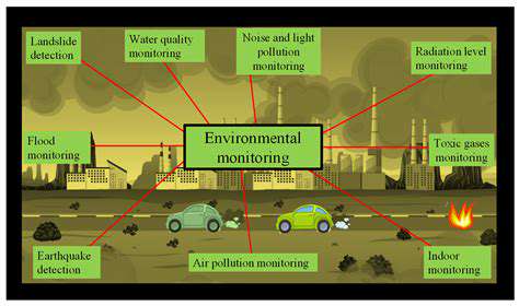
Environmental Monitoring for Air Quality
Air pollution poses a significant threat to human health and the environment. Accurate and timely monitoring of air quality is crucial for understanding pollution sources, identifying trends, and developing effective mitigation strategies. Environmental monitoring programs collect data on various pollutants like particulate matter, sulfur dioxide, nitrogen oxides, and volatile organic compounds. This data helps scientists and policymakers understand the impact of industrial emissions, traffic, and other human activities on air quality.
Monitoring stations strategically placed throughout an area can provide a comprehensive picture of air quality. This data is used to identify hot spots of pollution, assess the effectiveness of pollution control measures, and ultimately improve public health and environmental protection.
Monitoring Water Quality
Maintaining clean and healthy water bodies is essential for aquatic life and human consumption. Water quality monitoring involves analyzing various parameters such as dissolved oxygen, temperature, pH, and the presence of contaminants like heavy metals, pesticides, and bacteria. These parameters are crucial for assessing the overall health of aquatic ecosystems and identifying potential sources of contamination.
Regular monitoring helps to identify pollution sources, assess the effectiveness of treatment plants, and track the impact of natural events on water quality. Understanding water quality trends over time is essential for developing proactive strategies to prevent and manage water pollution.
Soil Monitoring for Environmental Health
Soil health is critical for agriculture and ecosystem stability. Soil monitoring programs assess factors like nutrient levels, soil pH, organic matter content, and the presence of pollutants like heavy metals. This data is used to understand the impact of agricultural practices, industrial activities, and other human interventions on soil health.
Understanding the composition and health of the soil is important for maintaining agricultural productivity and preventing soil degradation. Accurate and regular monitoring allows for the implementation of sustainable agricultural practices and the mitigation of soil contamination.
Impact on Biodiversity and Ecosystem Monitoring
Environmental monitoring plays a vital role in understanding the impact of human activities on biodiversity. It includes observing plant and animal populations, assessing habitat quality, and tracking the presence of invasive species. These data help scientists understand the interconnectedness of ecosystems and the effects of environmental changes on different species.
Monitoring biodiversity and ecosystem health is essential for conservation efforts. By tracking changes in species populations and habitats, scientists can identify areas needing protection and develop strategies for conservation.
Monitoring for Climate Change Impacts
Climate change is a global concern that necessitates comprehensive monitoring of its impacts on various environmental parameters. Monitoring programs track changes in temperature, precipitation patterns, sea levels, and ice cover. This data helps scientists understand the extent of climate change and its effects on different ecosystems.
Data from environmental monitoring is crucial for developing effective adaptation and mitigation strategies to address climate change. These strategies can reduce the impact of climate change on human populations and ecosystems.
Environmental Monitoring for Resource Management
Sustainable resource management requires a comprehensive understanding of available resources and their potential impacts on the environment. This involves tracking resource availability, including water, minerals, and forests. Monitoring data helps determine sustainable use levels and identify potential environmental degradation. This data is critical for ensuring that resources are utilized responsibly and that the environment is protected for future generations.
Environmental monitoring data is essential for developing policies and regulations to ensure responsible resource management. It facilitates informed decision-making about resource allocation and helps prevent overexploitation and environmental damage.
Food deserts, areas with limited access to affordable and nutritious food, create significant health and socioeconomic disparities. Addressing this challenge requires innovative solutions that go beyond simply increasing the number of grocery stores. These solutions must consider the unique needs and circumstances of the affected communities, including transportation limitations, financial constraints, and cultural preferences. Innovative strategies might include mobile food markets, community gardens, and partnerships with local farmers to provide fresh produce directly to underserved populations. Encouraging the development of community-based food hubs could also facilitate the distribution of healthy food options.
Beyond Environmental Monitoring: Applications in Disaster Relief and Precision Agriculture
Beyond the Basics: Expanding Environmental Monitoring
Environmental monitoring is crucial for understanding and mitigating the impacts of human activities on the natural world. While traditional approaches focus on collecting data on air and water quality, temperature, and species populations, a more holistic approach is necessary to truly grasp the complexities of environmental systems. This involves considering the intricate relationships between various factors, from climate change to resource depletion.
This expanded scope of environmental monitoring requires sophisticated technological tools and interdisciplinary collaboration. Researchers must work together to integrate diverse data sources, analyze complex patterns, and develop predictive models that can anticipate and respond to emerging environmental challenges. This proactive approach is essential for effective conservation and sustainable development.
Technological Advancements in Environmental Monitoring
Technological advancements have revolutionized environmental monitoring, providing unprecedented access to data and insights. Remote sensing technologies, such as satellites and drones, allow for large-scale observations of landscapes, ecosystems, and pollution patterns. This enables researchers to monitor vast areas in real-time, capturing valuable data that would be impractical or impossible to collect otherwise.
Integrating Social and Economic Factors
Effective environmental monitoring transcends purely scientific data collection. To understand the full impact of human activities, it's essential to incorporate social and economic factors into the analysis. This means considering human behaviors, economic pressures, and societal values that influence environmental choices and resource management. For example, the effects of poverty on deforestation and the role of cultural practices in conservation efforts need to be considered.
Understanding these interconnected factors allows for the development of more comprehensive and effective solutions for environmental issues. By considering the complex web of human interactions and environmental systems, we can create strategies that are truly sustainable and equitable.
The Future of Environmental Monitoring
The future of environmental monitoring lies in the integration of diverse data sources, advanced modeling techniques, and innovative technologies. This will allow for more accurate predictions of environmental changes, enabling proactive responses to emerging challenges. Furthermore, citizen science initiatives are increasingly important for expanding data collection efforts and engaging the public in environmental stewardship.
The ultimate goal is to develop a comprehensive framework for environmental monitoring that not only tracks changes but also predicts future trends, allowing us to proactively address and mitigate environmental challenges. This will require collaborative efforts from scientists, policymakers, and the public to build a more sustainable and resilient future.
Challenges and Future Directions
Swarm Satellite Constellations: Overcoming Challenges
Developing and deploying large constellations of small satellites, often referred to as swarm constellations, presents several significant technical challenges. These challenges range from the intricate coordination and precise control of numerous spacecraft in close proximity to the logistical complexities of launch, deployment, and long-term operation. Managing the potential for component failures, maintaining communication links across the constellation, and ensuring the reliability of data transmission and processing are crucial aspects of this endeavor. These challenges are compounded by the need for sophisticated algorithms to process the vast amounts of data generated by such a dense network of sensors.
Furthermore, the sheer volume of data generated by a swarm constellation necessitates powerful and efficient data processing infrastructure. The need for real-time analysis and interpretation of the data stream poses significant computational and storage challenges. Efficient algorithms and distributed processing architectures are essential for handling the data deluge and extracting meaningful insights from the combined observations of the swarm.
Data Integration and Fusion: A Critical Need
A key challenge in swarm satellite applications lies in integrating and fusing the data collected from individual satellites within the constellation. Each satellite might be equipped with different sensors and instruments, collecting data in various formats and resolutions. Developing standardized data formats and protocols, alongside sophisticated algorithms for data fusion, is vital to combine information from diverse sources and create a comprehensive and coherent picture of the phenomena being observed. The potential for discrepancies and inconsistencies in the data from different satellites requires careful consideration and mitigation strategies.
Addressing the Cost of Operation and Maintenance
The financial implications of deploying and maintaining a swarm constellation must be carefully considered. The cost of individual satellites, launch vehicles, ground stations, and ongoing operations and maintenance can quickly escalate, especially for large-scale constellations. Innovative approaches to reduce costs, such as using reusable launch systems, developing more efficient satellite designs, and leveraging cloud computing for data processing, are critical for making swarm satellite applications economically viable and sustainable in the long term. Exploring potential cost-sharing models among multiple stakeholders will also be crucial.
Ensuring Data Security and Privacy
The increasing reliance on satellite data for various applications necessitates robust security and privacy measures. Protecting the data collected by the swarm constellation from unauthorized access and manipulation is paramount. Developing secure communication protocols, implementing encryption techniques, and establishing robust data access controls are essential aspects of ensuring the integrity and confidentiality of sensitive information. Maintaining data privacy and compliance with relevant regulations is also a critical concern that needs careful consideration.
Future Directions: Expanding Capabilities and Applications
The future of swarm satellite applications holds immense potential for expanding the scope and capabilities of distributed sensing. Exploring new applications in environmental monitoring, disaster response, precision agriculture, and urban planning will be critical. Further advancements in sensor technology, communication protocols, and data processing algorithms will be essential to unlock the full potential of swarm constellations. Collaboration between researchers, engineers, and policymakers will be paramount in defining and addressing the future challenges and opportunities in this rapidly evolving field.