Beyond the Map: Utilizing Satellite Imagery for Deeper Insights
Modern satellite technology offers far more than basic visual maps. Advanced spectral analysis techniques can identify specific materials and environmental conditions, enabling detection of vegetation types, pollution sources, and other critical data points. When combined with additional intelligence streams, this creates a dynamic understanding of geographic areas that static maps simply cannot provide.
The evolution of high-resolution imaging coupled with temporal analysis reveals subtle but important landscape changes. Monitoring deforestation patterns, urban development, or military movements becomes possible through these detailed chronological comparisons. Such capabilities transform how analysts understand and predict complex global developments.
Geographic Data Fusion: Integrating Diverse Sources
Contemporary GEOINT practices incorporate multiple data streams including LiDAR scans, aerial photography, ground sensor networks, and even publicly available social media content. This multidimensional approach provides analysts with comprehensive situational awareness that single-source data cannot match.
Data fusion techniques enable correlation between seemingly unrelated information sources. For instance, cross-referencing satellite imagery with social media activity can reveal emerging civil unrest patterns, offering valuable predictive insights into socio-political developments.
Predictive Modeling with GEOINT
Forward-looking applications of geospatial intelligence now enable predictive analysis of various scenarios. Disease spread models, population displacement forecasts, and natural disaster predictions all benefit from sophisticated GEOINT methodologies. These applications have moved beyond theoretical exercises to become operational tools for disaster preparedness and national security planning.
3D Modeling and Simulation for Enhanced Analysis
The transition from static 2D maps to interactive 3D environments represents a quantum leap in analytical capabilities. Virtual terrain models allow for dynamic scenario testing and risk assessment that was previously impossible. Analysts can now simulate various conditions and outcomes, dramatically improving preparedness and response planning.
Real-Time GEOINT: Monitoring Dynamic Situations
Modern systems process geospatial data in near real-time, enabling immediate response to developing situations. This capability proves invaluable for disaster response, conflict monitoring, and counterterrorism operations, where minutes can make the difference between containment and catastrophe.
Open-Source GEOINT: Leveraging Publicly Available Data
The strategic incorporation of open-source intelligence with traditional GEOINT methods creates powerful synergies. Publicly available satellite imagery, social media content, and news reporting can significantly enhance classified intelligence products when properly analyzed and verified.
The Future of GEOINT: Emerging Technologies and Innovation
Machine learning algorithms now automate complex pattern recognition tasks in geospatial analysis. This technological leap is transforming GEOINT from a reactive tool to a predictive analytical system, with profound implications for everything from urban planning to national security.
The Interplay of GEOINT with Other Intelligence Disciplines
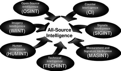
The Fusion of GEOINT with Intelligence
Geospatial intelligence serves as a force multiplier when combined with other intelligence disciplines. Its unique visualization capabilities provide critical context that enhances understanding of complex operational environments. This integrated approach reveals patterns and connections that might otherwise remain obscured.
The Synergy with Human Intelligence (HUMINT)
Field intelligence gains tremendous value when corroborated with geospatial data. The combination of on-the-ground human reporting with overhead imagery creates verifiable, actionable intelligence essential for national security operations and strategic planning.
GEOINT and Signals Intelligence (SIGINT) Integration
When geospatial data intersects with communications intelligence, analysts gain both location and content context. This powerful combination proves particularly effective for tracking illicit networks and monitoring potential security threats across global hotspots.
GEOINT and Measurement and Signature Intelligence (MASINT) Collaboration
The marriage of geospatial analysis with specialized sensor data creates unprecedented detection capabilities. Subtle environmental changes that might indicate covert activities become detectable through this interdisciplinary approach.
GEOINT Supporting Open Source Intelligence (OSINT)
Geospatial analysis serves as a critical verification tool for publicly available information. By providing ground truth context, GEOINT helps separate signal from noise in the vast ocean of open-source data, significantly enhancing its intelligence value.
The Role of GEOINT in Countering Terrorism
Counterterrorism operations rely heavily on geospatial intelligence for pattern analysis and predictive modeling. The ability to identify training camps, monitor movement patterns, and track logistical networks makes GEOINT indispensable in global counterterrorism efforts.
GEOINT in Crisis Response and Disaster Management
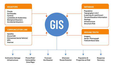
GEOINT's Role in Disaster Assessment
Geospatial intelligence provides the foundation for rapid damage assessment following natural disasters. By creating comprehensive overviews of affected areas, responders can prioritize resource allocation and coordinate relief efforts with unprecedented efficiency.
Mapping and Monitoring Damage
Detailed damage assessment maps enable targeted response operations. The ability to identify compromised infrastructure in real-time dramatically improves disaster response effectiveness while also informing long-term recovery planning.
Supporting Search and Rescue Operations
Geospatial data proves life-saving in locating survivors amidst disaster zones. Precision location services become particularly crucial when traditional communication networks fail, guiding rescue teams to those most in need.
Predictive Modeling and Risk Assessment
Advanced GEOINT applications now enable forward-looking disaster preparedness. By analyzing historical patterns and current conditions, governments can implement preventative measures before disasters strike, potentially saving countless lives.
Communication and Coordination
Shared geospatial platforms create common operating pictures for diverse response agencies. This interoperability prevents duplication of effort and ensures optimal resource deployment during critical emergency response operations.
The Future of GEOINT and Emerging Technologies
The Integration of Artificial Intelligence
AI-driven analysis is transforming geospatial intelligence processing. Machine learning algorithms can process vast datasets far beyond human capacity, identifying subtle patterns that inform strategic decision-making. This technological evolution is shifting analyst roles toward higher-level interpretation and contextual understanding.
Quantum Computing's Impact
Though still in developmental stages, quantum computing promises revolutionary GEOINT capabilities. Complex environmental modeling and signal analysis that currently take days could become near-instantaneous, opening new frontiers in geospatial understanding.
Advancements in Sensor Technology
Next-generation sensors provide unprecedented data granularity. Hyperspectral imaging and advanced LiDAR systems enable material characterization and terrain mapping at levels of detail previously unimaginable, significantly enhancing analytical precision.
The Role of Big Data and Cloud Computing
Modern GEOINT operations require massive data infrastructure. Cloud-based solutions enable real-time collaboration and analysis across global intelligence communities, while integrated data streams create comprehensive operational pictures.
Enhanced Visualization and Data Sharing
Next-generation visualization tools transform raw data into actionable intelligence. Interactive 3D models and dynamic mapping platforms improve both analysis and decision-maker comprehension, while secure sharing protocols enhance multinational security cooperation.