Multispectral imaging, a technique that captures images across a broad spectrum of wavelengths, provides a rich dataset of information beyond what the human eye can perceive. This detailed information can reveal subtle variations in surface properties, composition, and even health conditions that would otherwise remain hidden. By analyzing the reflected light at various wavelengths, multispectral sensors can differentiate between different materials, even when they appear visually similar. This capability is particularly valuable in agriculture, where it can help farmers assess crop health, identify areas needing irrigation, and monitor nutrient levels.
The ability to measure reflectance across multiple wavelengths allows for a more comprehensive understanding of the scene. This detailed view is crucial in various applications, from environmental monitoring to geological surveys. For example, in environmental monitoring, subtle changes in vegetation cover or water quality can be detected, providing valuable insights into ecological processes and potential environmental threats.
Hyperspectral Imaging: Going Deeper into the Spectrum
Hyperspectral imaging, a more sophisticated form of multispectral imaging, goes beyond capturing a few wavelengths to acquire data across hundreds or even thousands of narrow spectral bands. This significantly increased spectral resolution allows for a more detailed analysis of the target object. This higher resolution allows for the identification of very subtle differences in composition, which can be difficult or impossible to discern using traditional methods.
This advanced technique has widespread applications in diverse fields, including material science, where it can help identify the exact chemical composition of materials, and medical diagnosis, where it can aid in detecting early signs of disease.
Applications in Agriculture and Environmental Science
Multispectral and hyperspectral imaging are revolutionizing agriculture and environmental science. In agriculture, these techniques help monitor crop health, identify areas needing irrigation or fertilization, and assess the overall productivity of farms. This allows for more efficient resource allocation and minimizes environmental impact.
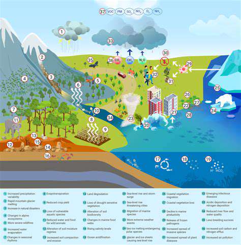
In environmental science, these methods provide valuable data for monitoring deforestation, assessing water quality, and identifying areas of soil degradation. This data is essential for understanding and mitigating environmental problems, enabling more informed decision-making. Real-time monitoring can reveal the impact of environmental changes, allowing scientists to understand the dynamics and patterns of ecological systems.
Beyond the Visual: Applications in Materials Science and Medicine
The capabilities of multispectral and hyperspectral imaging extend far beyond agriculture and environmental science. In materials science, these techniques can identify the chemical composition and structure of materials with unprecedented accuracy. This has significant implications for the development of new materials and the improvement of existing ones. This detailed analysis allows scientists to understand the properties of materials at a molecular level, leading to advancements in various fields.
In medicine, hyperspectral imaging has the potential to aid in early disease detection and diagnosis. It can help differentiate cancerous tissue from healthy tissue, allowing for earlier and more effective treatment plans. This approach has the potential to significantly improve patient outcomes by allowing for faster and more accurate diagnoses.

Future Directions and Technological Advancements
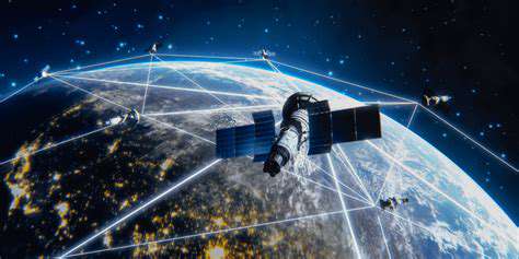
Orbital Constellation Architectures
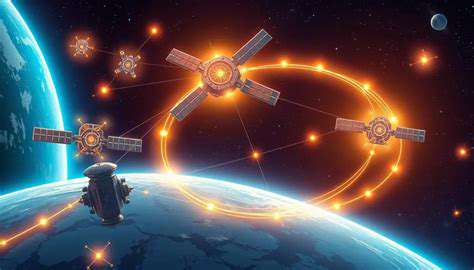
The future of space-based remote sensing hinges significantly on the deployment of sophisticated orbital constellations. These interconnected networks of satellites, meticulously designed for specific observational tasks, will enable higher spatial and temporal resolutions than ever before. A crucial aspect of this development will be the optimization of satellite orbits to maximize coverage and data acquisition efficiency. This will involve deploying satellites in various orbital planes, potentially leveraging existing infrastructure like the International Space Station or developing novel launch systems for more frequent and cost-effective deployments.
The complexity of managing such constellations demands advancements in satellite communication protocols and data processing algorithms. Real-time data transfer and analysis are essential for timely responses and actionable intelligence. This will require breakthroughs in both satellite-to-ground communication systems and on-board processing capabilities to reduce the data volume transmitted to Earth, thereby improving efficiency and minimizing latency.
Advanced Sensor Technologies
Innovations in sensor technology are critical for pushing the boundaries of space-based remote sensing. This includes the development of more sensitive and precise instruments capable of detecting subtle changes in the Earth's environment. For example, advancements in hyperspectral imaging will allow for more detailed analyses of the composition and properties of materials on the ground, providing insights into agricultural health, environmental changes, and even geological formations.
Furthermore, the integration of artificial intelligence and machine learning algorithms into sensor systems will enable automatic target recognition, anomaly detection, and improved data interpretation. This will significantly reduce the workload on human analysts and allow for faster, more comprehensive analysis of vast amounts of remote sensing data.
Data Fusion and Analysis Techniques
The sheer volume of data generated by these advanced constellations necessitates sophisticated data fusion and analysis techniques. Combining data from various sensors, including optical, radar, and thermal, will provide a more comprehensive and nuanced understanding of the Earth's surface and its dynamic processes. This integrated approach will allow for a more holistic picture of environmental changes, resource management, and disaster response.
Moreover, the development of new algorithms for processing and interpreting multi-source data will be crucial. This includes algorithms that can account for the inherent biases and limitations of each sensor type, enabling more reliable and accurate interpretations of the data. This will lead to more robust and actionable insights for a wide range of applications.
Integration with Ground-Based Systems
Effective utilization of space-based remote sensing data relies heavily on seamless integration with ground-based systems and infrastructure. Developing robust communication networks and data processing platforms that connect space-based systems with ground-based monitoring stations will be crucial. This will allow real-time data sharing, facilitating collaboration among researchers, policymakers, and other stakeholders.
By facilitating the flow of information between space and ground, these integrated systems will enhance the accessibility and applicability of remote sensing data, leading to more efficient and effective decision-making in various sectors.
Applications in Environmental Monitoring
Space-based remote sensing is poised to revolutionize environmental monitoring, providing unprecedented insights into environmental changes. The ability to track deforestation, monitor water resources, and detect pollution in real-time will be instrumental in mitigating environmental damage and fostering sustainable practices.
Applications in Disaster Management
Early detection and rapid response to natural disasters are critical for minimizing casualties and damage. Space-based remote sensing can play a vital role in providing real-time information on disaster events, such as floods, wildfires, and earthquakes. This early warning capability will be critical in enabling timely evacuation efforts and resource allocation.
Advancements in Spacecraft Technology
The development of more reliable, robust, and cost-effective spacecraft will be essential for the widespread adoption of space-based remote sensing. Improvements in propulsion systems, spacecraft durability, and on-board power generation will minimize mission costs and increase the lifespan of satellites, allowing for more sustained observation campaigns.
Furthermore, advancements in miniaturization and modular design of spacecraft will enable the creation of increasingly complex and versatile constellations at a more manageable cost, paving the way for more frequent and varied applications of remote sensing technology.